General Plan
Provisional Schedule
Safety Plan
Post Event Report
From Max Finklestein
This inaugural Pinesi Paddle retraced Algonquin Grand Chief Constant Pinesi’s route from his annual summering place at Oka, Que. to his hunting grounds in Ottawa. The Brigade left June 26th from Oka National Park, Que. Pinesi was one of the last traditional chief residents in the Lower Ottawa River, until he was obliged to move to Algonquin Park.
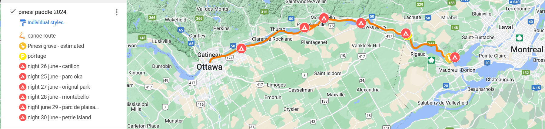
Led by Algonquins from Pikwakanagan First Nation, the 154 km, 6-day paddle along the Ottawa River included direct descendants of Chief Pinesi, other indigenous people, and settlers. The Pinesi Paddle began in Oka (at the parc national d’Oka)and ended in Ottawa on Canada Day – with ceremonies, drumming and dancing at each end, and reconciling with communities around campfires in between.
Paddlers included direct descendents of Chief Constant Pinesi, who came from as far away as Wisconsin and Saskatchewan, and other Anishabe Algoqnquin and settlers. The voyage had different meanings for each of the paddlers. For some, it was about honoring ancestors. For others, it was a physical challenge (and due to the high water, strong currents and seemingly ceaseless headwinds, it was much more of a physical challenge than anticipated.). For other participants, it was about grieving loved ones and lost culture, or a drug and alcohol healing journey. For many settlers, it was about ally-ship with indigenous people.
The Pinesi Paddle for Peace ended with paddlers walking along the ancient portage trail connecting the Ottawa and Rideau rivers in what is now New Edinborough.
The daily practice of the paddling journey included efforts towards reconciliation. This not only occurred amongst the paddlers themselves, but also took place at the mostly francophone communities along the route, where mayors, community leaders and local historians graciously hosted the paddlers and celebrated the event.
Campsites and lunch stops along the route included Oka, Rigaud, Hawkesbury, Orignal, Fasset, Montebello, Papineauville, Plaisance Park, and Petrie Island.
The 350th Anniversary of the Seigneury of Petite Nation coincided with the arrival of the brigade at Montebello, where Mayor Nicole Laflamme and former Pikwakanagan Chief Wendy Jocko unveiled the Kichi Sibi Trails logo on the lighthouse.
On arrival in Ottawa, the brigade was met by a flotilla from the New Edinborough Boat Club, and other greeters on the shore. Paddlers walked along the ancient portage route to the Fieldhouse. Welcoming ceremonies led by the traditional and council leadership of the Algonquins of Pikwakanagan First Nation (AOPFN) including Kokom Jane Chartrand, Chief Greg Sarazin, Wendy Jocko and Councillor Merv Sarazin, and local dignitaries MP Mona Fortier, MPP Lucille Collard, and Rideau-Rockcliffe Councillor Rawlson King greeted the paddlers. Paddlers shared their experiences at a Roundtable discussion, buoyed by drumming, and dancing. Chief Pinesi Day provides a way for indigenous people to celebrate on Canada Day, without celebrating colonialism.
Events coordinators were members of the AOPFN, Kichi Sibi Trails, the Archdiocese of Mont Laurier and Crichton Community Council. Financial contributions have been made by Infrastructure Canada, New Edinburgh Community Alliance, AOPFN, Tricycle, Blaney McMurtry and Innovation 7, and the CVBS.
Brigade Route: Montreal to Ottawa (upstream!)
May 05 – Update from Max. An expected grant has not been received and Max is nearing his present limits for the three big canoes that he has. Max is suspending further registrations until a number of early prospects are confirmed. You may contact Max to determine the potential for registration and ask to be put on a waiting list.
April 15 – At present all paddlers, and crew leaders with a partial or full crew should email Max to confirm their interest in this brigade, big canoe experience, and how the may help him out forming crews, and finding additional big canoes for this brigade. Given that this is a small brigade Max expects to register and form crews largely by email and phone calls.
contact for further info: Max Finklestein <dowfink@gmail.com>
